
S/V Tango cruise to Haida Gwaii 2018
1976 Kelly-Peterson 44 #115
Haida Gwaii ("Islands of the Haida people") is an archipelago comprising about 150 islands lying 70 nautical miles offshore from the British Columbia coast and about 100 nautical miles north of Vancouver Island. Formerly known as the Queen Charlotte Islands, the archipelago is the home of the Haida First Nations people, who make up about half of the population of the islands. There is evidence of human occupation for at least 13,700 years. The Haida are famous for their sea-going dugout canoes, some as much as 70 feet in length, for their canny trading ability, their beautiful formline art style, and their fearsome reputation as raiders and slave-takers. Their matrilineal society is rich in tradition and ceremony, including great potlatches.
Often called the "Galapagos of the North," the islands include many endemic and isolated species that survived the Ice Age. The biomass density, both marine and terrestrial, is among the greatest on Earth. Much of the southern half of the archipelago is in Gwaii Haanas, a National Park Reserve and, at the southern end, World Heritage Site.
Tango visited Haida Gwaii in 2009 (see the log here). This voyage will include two weeks ashore, when we rent lodging in the village of Queen Charlotte and explore the islands by road and hiking trail. Want to see where Tango is? Click here. You can send us a message via this link.

At Olympia, Washington, where Tango is usually berthed, the halves of our dinghy, Clara T, wait on the dock before we joined them together and launched her into Budd Inlet.
May 16, 2018. We left Olympia before 7:00 AM and arrived at Port Townsend twelve hours later, setting a boat record for the 82 mile passage. We caught the first of the ebb tide out of Budd Inlet and rode a favorable current for most of the day. At times, we almost doubled our 6.3-knot cruising speed thanks to the outgoing tide.

A long day of motoring from Olympia to Port Townsend, the length of Puget Sound.

Along the way, we met a barge of the Alaska Marine Lines. Most freight to and from Alaska moves by barge.

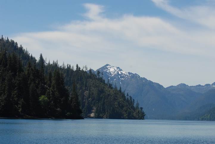
The Olympic Mountains still have some snow.

Port Townsend has saved many old buildings in downtown. The city was formed before Seattle with hopes that it would be the major port in the Pacific Northwest.

There are more wooden boats (with wooden spars) in Port Townsend than anywhere we have sailed.

The schooner Alcyone is beautifully maintained.


The Washington State ferry approaching Port Townsend.

A gaff-rigged ketch out of Port Townsend.

Water and clouds make a fascinating, ever-changing kaleidoscope.

The view from the pilot’s seat.
May 20, 2018. Campbell River, B.C. Peter left the boat three days ago, leaving Susi and me to sail north. We crossed into Canada on May 18, passing through Canadian Customs at Sidney with no problems. After a quiet night at Montague Harbor on Galiano Island, we motored north through the Strait of Georgia to False Bay on Lasqueti Island. The bay is exposed to the southwest. Fortunately, the wind was calm until we were ready to weigh anchor this morning. Then the “Qualicum wind” picked up, sending waves into our anchorage. These winds reach the Strait of Georgia through a gap in the Vancouver Island mountain chain, blowing across the Strait from the west over Qualicum Beach. The waves were two to three feet high, driven by 25-knot wind on our beam. Tango rocked and rolled, plunging down into the waves and spraying water over the cockpit dodger. But we were snug within the covered cockpit. An hour later, the wind dropped to under ten knots and came from the north, dead ahead. It would have taken twenty minutes to raise the sails for forty minutes of sailing, so we just motored through the wind.
We got to the fuel dock at Discovery Harbour Marina in Campbell River just a few minutes after Bob Durnell, who had flown in from Eugene to help us sail to Haida Gwaii. The timing could not have been better. We stayed the night at the marina, getting ready for a morning run through dreaded Seymour Narrows tomorrow on a favorable tide.

A First Nations cemetery near the Discovery Harbour Marina in Campbell River.

Along the trail north to the mouth of
Campbell River.

Tugs at Campbell River.
May 21, 2018. We left the Campbell River dock
an hour and a half before the turn to ebb, bucking a two-knot adverse current
seven miles to Seymour Narrows, one of the most dreaded passages in the Inside
Passage. We got to Ripple Rock a few minutes before slack. There was little
turbulence and little adverse current as we passed over the rock. In the late
1940s, the top 40 feet of the rock was blown off in the biggest non-nuclear
explosion to date (it’s worth watching on YouTube). Before then, many vessels
had been wrecked and many lives lost on the rock.
We rode the ebb current through Johnstone Strait, boosting our speed by 50 percent at times, on a calm and windless day, and set anchor in a snug cove in Port Harvey. I put a crab trap out, hoping for the same success that Bob Guza and I had a few years ago when we set a boat crustacean record in a nearby cove.
May 22, 2018. Unfortunately, Neptune was stingy with his crabs. When the trap came to the surface, there was only one forlorn red rock crab (missing his forelimbs and pincers). He was released with best wishes for good luck.

Port Harvey is a secure anchorage, but not much for scenery. The head of the inlet is occupied by a large logging operation on barges. There is a marina, but repeated calls on the VHF radio did not get a reply, so they might not be open for the season.

We decided to take a short day’s cruise into Knight Inlet, a steep-sided fjord several miles long. When we turned into the inlet, we found a 20-knot tailwind, so we unfurled the headsail, turned off the engine, and sailed for an hour. Of course, we had to turn around and head back upwind eventually to get to our next anchorage, so we furled the sail again, started the engine, and charged headlong into the waves and wind. We anchored in Cracroft Inlet, hoping to replicate the success we had here crabbing on a previous voyage.

Susi at the wheel, enjoying the sailing in Knight Inlet.
May 23, 2018. When I pulled up the two crab traps, I found a total of 13 crabs. Unfortunately, most were female (which must be released) and only one male was legal size. We killed, cooked, and cleaned it and had it in a salad for lunch. We motored through the fog and low clouds to Port McNeill, where we refueled and tied up to the dock. Bob Guza arrived in the early evening, having flown from San Diego to the Port McNeill/Port Hardy airport.
May 24, 2018. We’re facing passage across Queen Charlotte Strait, an open water passage exposed to everything the Pacific can deliver. The forecast predicts 10-15 knot winds on our nose (northwest) for most of the passage, with 1- to 2-meter seas. Not favorable. But the days following look worse. Bigger winds, bigger waves. We have a couple of days extra in our itinerary to allow us to wait out adverse weather, but we want to make some progress. We set off toward one of the last secure harbors before Cape Caution. We worked our way upwind, Tango splashing, yawing, and rolling with the seas. Instead of turning off into our refuge harbor, we decided to press on around the cape to Rivers Inlet.

As we got into flatter water in the inlet, Bob D roasted chicken and vegetables. We found a secure anchorage at the end of Goose Bay, set the anchor and the crab traps, and feasted. We decided to stay anchored the next day. We have only 50 miles to go to meet Sandy Liberty in three days, and we’ve earned a vacation after so many long days of working our way north.

A private float plane flew to the old Goose Bay cannery, now a private resort, and later idled out to set crab traps.
May 25, 2018. With Bob G aboard, I rowed Clara T to the crab pot buoys. As I pulled up the first, it felt heavy. I was optimistic. I could barely get it into the boat. Bob and I both said something like “Holy crabs, man!” as we looked into the trap at the dozen crabs within. As Bob pulled them out, we realized that they were all males and all more than legal sized. We kept a few and released the rest. We still had to pull the second pot, so as I rowed, we agreed to release all the animals within. It came up with five crabs, all legal-sized males. We kept the two biggest despite our resolution. Our five-gallon bucket could hold no more and the crab on top kept escaping. We later calculated the odds of catching all males if females and males were equally abundant—way less than one in a million (for the nerds, one over two to the 17th power).
Susi called out and asked why we didn’t keep them all. Later, she found the answer as we killed, cleaned, cooked, and processed our bounty. After hours of messy, steamy work, we ended up with two tubs of cleaned crab meat. Bob D cooked a crab omelet for brunch. Let the feasts begin!
May 26, 2018. We motored to Pruth Bay, where we tried to anchor near the Hakai Institute, which provides free wi-fi to boats in the bay. Unfortunately, the wind was so strong and the water depth so great that by the time we got out enough anchor rode, we were almost on the shore. So we pulled up the anchor and went to a nearby cove where there were no other boats and lots of swinging room. Unfortunately, no wi-fi, but we slept better knowing we wouldn’t swing into another boat or onto the rocks. Crab feasting continues. We have had crab salad, crab crepes, and crab cakes.
May 27, 2018. We enjoyed a 25-knot tail wind with the headsail up for four hours in Fitzhugh Sound. When we turned into Lama Channel, the wind died so we started the engine and motored to Shearwater Marine Resort. As we tied up to the dock, Sandy arrived on the water taxi from New Bella Bella, where the airport is. Another perfectly-timed rendezvous! We shopped at the well-supplied little store, got groceries, beer, and ice, and ate crab marinara for dinner.
We had some misadventures with the showers. Susi tried first, using shower A, and got only a few seconds of shower water for her loonies (Canadian dollar coins). She had to finish rinsing in the sink in the shower room. I used shower B and got a nice ten-minute shower for three loonies. Bob D tried shower C and found the coin box kept kicking out his loonies. He washed in the sink. As it turns out, older coin boxes won’t accept some of the loonies in circulation. There must have been different production runs. Bob G, scientist that he is, took note of the evidence and waited for shower B even while the others were unoccupied.


A new mural at Shearwater honors the natives, the founders, and other important persons.
May 28, 2018. Susi, Sandy, and I took off for a walk early on a sunny, calm morning. Within 20 minutes, the heavens burst forth with a deluge of cold rain. Only Sandy was wearing rain clothes, but she was the one who finally had the sense to say we should turn back. Just when we got back to Tango, the rain stopped and the sun came out. After buying several bags of ice and drying our soggy clothes at the laundry, we set off for a six-hour voyage to a snug cove in Meyers Passage.
May 29, 2018. We caught two crabs last night. It was almost a relief not to catch more because it takes so long to clean and cook them, but of course we always hope for a bounteous catch. We motored seven hours to Dunn Inlet in Campania Island, where we set the anchor at high tide in a little cove near the mouth of the inlet. When we took the dinghy out to set the crab traps, we encountered a lot of kelp anchored to the rocky bottom. We looked for a kelp-free area to set the traps, not wanting to pull the trap up through a kelp forest.
Bob G and I went off in the dinghy in pursuit of fish. At the mouth of the inlet, Bob caught a rockfish on almost every cast. We had to quit sooner than we wanted when we had our limit. Bob D cooked a wild rice dressing, stuffed the fish with it, wrapped it in foil, and cooked it on the grill. Tender, tasty, flaky white meat! With Susi’s salad and my fresh-baked bread and cookies, we feasted. We went to bed early, the sky still bright at 10:00 PM, so we could get up early and make a long day’s passage (103 miles).
May 30, 2018. We started pulling the anchor at 05:30. As it got to the surface, Susi called out that it was tangled with kelp and wouldn’t come all the way up. It was a huge ball of kelp, perhaps three or four feet in diameter, completely covering the anchor. Bob D and Susi had at it with boat hooks, pulling strands off and casting them aside. After ten minutes of strenuous work, we were able to bring the anchor aboard. We motored cautiously out of Dunn Inlet, now at low tide with lots of kelp and rock showing, and set off.
Hecate Strait is notorious for big wind, big waves, and challenging conditions. We had been following the weather forecast for a few days and it looked as if this was the day for an easy passage—calm winds, no choppy waves, and just a low swell from a distant storm. It turned out to be so calm and the seas so quiet that we could have been on one of the inner channels. Occasionally a little breeze would ruffle the water, but for the most part it was glassy calm. Even Bob G, despite being prone to mal-de-mer, had no trouble at all. For most of the crossing, he stayed in the cabin reading New Yorker magazines. We got into Bearskin Bay, Skidegate Inlet, after sixteen hours of motoring. The sound of the chain rattling out as the anchor dropped was a welcome noise.


The public docks at the Village of Queen Charlotte.
May 31, 2018. We called our host and our car rental agent. The house was ready and so was the car, even though we were a day early for our reservations. Bob G and I rowed ashore, got the keys and instructions, and rowed back to Tango. Then I took Bob G and Sandy ashore so they could drive the car to the ferry, cross the inlet, and then to the Sandspit Harbour Authority marina. Bob D and I motored Tango across the inlet and tied her to the dock, where Bob G and Sandy met us, loaded goods, gear, and clothing into the car, and returned to the Village of Queen Charlotte (“Charlotte” to the locals).
June 1, 2018. We drove to Skidegate and hiked the rugged Lookout Trail near the Haida Heritage Center. Although it was only four miles, it was a lot of vertical and a lot of scrambling on a partially-developed trail. We found lots of oyster mushrooms on dead alder trees—later in the day, we sautéed them and had them for dinner.

Bob D picking oyster mushrooms.

The Lookout Trail.
June 2, 2018. We took a tour with Moresby Explorers in a high-speed Zodiac boat. The guides in a van picked us up at the ferry terminal on the south side of the inlet, drove us for an hour on logging roads to Cumshewa Inlet, gave us life vests, rubber rain suits, and heavy rubber boots, then loaded us aboard the boat.

Niece Sandy and Uncle Bob G in rubber suits.

We blazed over the water, driven by a 225-horsepower outboard, to the site of an old logging camp, where we disembarked on the beach. Our guides, Jessie and Ollie, walked us through the long-abandoned camp, where we marveled at the machinery left behind. There were trucks with hard rubber tires, a steam donkey once used to winch logs out of the woods, fragments of boots, clothing, cookware, bottles…whatever wasn’t worth hauling out was just left.

This steam donkey once hauled logs out of the woods with cables and chokers.

Log trucks with hard rubber tires ran on a “track” of planed logs to haul logs out of the forest to the landing. They were abandoned when logging stopped.

Shelf fungi and moss thrive in this wet forest.

Our guides serving lunch.
After lunch, we got back into the boat and continued racing around Louise Island. Our next stop was the village site of Koona (a.k.a. Skedans), where we were given a tour by a wonderful elder who shared stories of her family and her village. Most of the poles have fallen or are on their way down. The houses have all collapsed. A few of the major roof beams remain identifiable. Trees are growing out of the decomposing remains of once-great poles.

All that remains of a once-great house is the excavated pit and a few roof beams.

A few poles still stand, albeit precariously.

The number of rings on this memorial pole indicates how many potlatches the chief gave in his lifetime.

After a couple of hours at the village, we scooted back to the launch site, loaded into the van, and worked our way back to the ferry landing. As we boarded another Zodiac for the trip across the inlet to Charlotte, the skipper told us we were the first paying passengers aboard the vessel—it had been launched for the first time two hours before. I asked him how much the boat cost--$150,000 CDN was the reply (including the motor).
June 3, 2018. Susi, Sandy and I took a long hike along the Tlell River, north of Skidegate Inlet. It was a beautiful walk through the forest next to the river all the way to the beach, full of interesting plants, fungi and scenery. We found more oyster mushrooms and had to stop ourselves from picking more when we had half-filled a large grocery bag with them. Bob D roasted a big, locally-raised chicken in the barbeque at our rental house. We had stopped at a farmers’ market in Tlell, where we bought an apple pie and a loaf of sourdough rye bread, so we had a feast (yet again)!

The tree that Sandy is facing germinated on a nurse log that is now long gone. A long root, once atop the fallen giant, now acts as a strut to hold the tree upright.

This tree has a see-through where the nurse log once was.

Coral-root, a non-photosynthetic orchid that gets its nutrients from soil fungi, emerges from the soil only to flower.
June 5, 2018. Jill Liberty and Sally Guza flew in to the Sandspit airport on a blustery day, with driving rain and wind sustained at 35 knots, gusting to 50. The next day, we celebrated Bob G’s 70th birthday with cupcakes and candles. Walks on the beach and in the forest occupied much of our time. Weather ranged from sunny and mild to rainy and windy, often in quick succession.

Near Charlotte, a giant spruce stump took seven arm spans to circle (about 42 feet in circumference). The notches are where the hand loggers drove in the springboards upon which they stood as they used axes and a crosscut saw to cut the tree down. Chainsaws came into widespread use in the late 1940s, indicating that this tree was cut at least 70 years ago. Scattered big stumps remain among the dense second growth along the Crabapple Creek trail.

The beach near Charlotte.

Bob and Sally look for pretty rocks at Jungle Beach, northeast of Charlotte.

Jill stands next to a glacial erratic at Jungle Beach. The glaciers that once covered the islands left many stones behind as they receded. The smaller ones have been rounded by the surf, leaving a classic shingle beach.
June 11, 2018. We went north to Masset at the northern edge of Graham Island. At the harbor, we were hoping to buy fish at the dock, but none were available. It’s rather ironic that fresh fish is not available in the grocery stores along the Inside Passage. One explanation is that no locals need buy fish—they can catch fish themselves or rely on the generosity of their fishermen neighbors. The only place we were able to buy fish was at the farmers’ markets in Tlell and Charlotte, where a vendor had frozen fish. Bob bought a 2.5-pound fillet of ling cod. It was so much fish we expected to have leftovers but when he baked it, lightly seasoned, we ate it all in one meal.
From Masset, we drove east to Agate Beach. Bob and Jill found so many beautiful stones that they stuffed their pockets full and had to hold up their pants to get back to the car. In the distance, Tow Hill marks the most northeasterly point in the islands.

Rocks galore at Agate Beach.
June 15, 2018. Sally and Jill flew home in the past couple of days. Bob G, Susi, and I loaded all our stuff back into Tango yesterday at low, low tide, which means that the ramp to the docks was steeeeep. We didn’t dare take a loaded dock cart down for fear of its running away, so we parked one at the bottom and carried the stuff down two bags at a time. After taking on 233 liters of diesel fuel, we made our way north this morning.
After making enough northing to clear the shoals at the mouth of Skidegate Inlet, we headed south. Hecate Strait was rough. Swells and waves were coming from at least two directions (N and NW), leading to lots of rocking and rolling. There wasn’t enough wind to raise the sails for a speed boost, but later we thought that it might have been wise to raise the mainsail and keep it sheeted in tight to counter the rolling. We anchored at Cecil Cove in Selwyn Inlet, where Bob and I caught six crabs and two big sculpins. We cooked bouillabaisse with the sculpins and two of the crabs. With green salad, home-made dressing, and fresh crusty bread, we feasted.

June 16, 2018. We saw four orcas in Logan Inlet. We have been astounded at how few sightings we’ve made of marine mammals. When Bob D and I were here nine years ago, humpback whales were abundant. Pacific white-sided dolphins would show up by the hundred. This time, we’ve seen no humpbacks and few orcas or dolphins. A few sea lions and several seals have been spotted.

A bear patrols the intertidal zone at low tide, turning over rocks to find food.
Snow-capped mountains tower over Gwaii Haanas.
June 17, 2018. We motored from our anchorage, Hutton Inlet, to Hotsprings Island. Susi and Bob went ashore to tour the remains of the village and soak in the hot pools. Their timing was right—they had the pools to themselves. As they were leaving, a tour group of more than a dozen people approached.

Clara pulled up on the beach at Hotsprings Island.
The view from the hot springs.
June 18, 2018. We made a four hour passage from last night’s anchorage, Island Bay, to Slim Inlet. Susi went ashore and hiked to the head of the inlet, where she met a black bear headed toward her through a grassy meadow. She was downwind and, given the bear’s poor eyesight, he was unaware of her. A veteran of many bear encounters, she knew just what to do. When he got close, she said, “Hey, bear! That’s close enough.” He stopped, stared, sniffed. She waved her arms so he could see her. He turned walked calmly away. She said, “Thank you, bear.” She described it as a peaceful, respectful encounter.
June 19, 2018. We stayed in Slim Inlet, waiting for better weather to cross Hecate Strait. Susi read in a guide book that it might be possible to walk from the head of Slim Inlet to the head of Louscoone Inlet to the south. It sounded like a challenge, so she set off to find the route. It was sparsely marked by red flagging tied in trees, but it couldn’t be called a developed trail. A few fallen trees that blocked the way had been cut to allow passage, but other than that there wasn’t much improvement. The route was boggy at times, a scramble at others. She made it to Louscoone Inlet, but when she got back to Slim Inlet, it was high tide and the beach route was underwater. She called on a handheld VHF radio and I went to get her in the dinghy.

Slim Inlet.

On Susi’s trek from Slim Inlet to Louscoone Inlet.

A big tree along the “trail.”

Water lilies and bogs.

Moss covers almost everything.

A culturally modified tree. The bark has been stripped to make cordage, mats, baskets, or hats. An inspection hole has been carved into the trunk to determine whether the tree was sound enough to make a canoe, pole, or house beam.

Sunset in Slim Inlet.
On the nearby beach, I found lots of fossilized wood. Some were barely-exposed fossilized logs a dozen feet long or more.

A buried fossil log.

A big chunk of fossilized wood.

Dawn at Slim Inlet.
June 20, 2018. The forecast looked good, so we weighed anchor at 2:00 AM to cross Hecate Strait. It was dark! The moon had set and it would be another hour before the eastern sky started to lighten. It was a little unnerving to motor through rocks, reefs, and islands by chartplotter and radar, but we came through unscathed. When we got into the Strait, there was a low swell and a 20-knot north wind. I put up the sails and we motorsailed for hours through the fog. Nineteen hours after leaving Slim Inlet, we anchored in Strom Cove, Campbell Island. The sun was out, snow-covered mountains towered over the mainland, and we felt good about the passage. Two small fish boats joined us in the cove, the first time we’ve shared an anchorage since leaving Sandspit. In all the time we were in Gwaii Haanas, we saw only a handful of boats, most of them at Hotspring Island. Some days we saw no other boats.
June 21, 2018. We motored a few miles and landed at the Shearwater fuel dock. We filled our diesel tanks, bought some groceries, and headed south through lots of marine traffic to Goose Bay. We anchored where we had such good success crabbing on the way north.
June 22, 2018. Again, we had a spectacular catch--fourteen big Dungeness crabs. We kept only six. We raised the anchor at 6:00 AM and headed south to round Cape Caution. Bob quickly killed, cleaned, and cooked the crabs. Susi spent a couple of hours cleaning the meat out of the shells as we motored through low swells and nearly calm wind. We arrived at Port McNeill eleven hours later and tied up at the municipal dock.

Dennis and Bob returning from setting the crab traps.

Bob killing a crab the Haida way—hitting him in the middle of the underside with a two-pound hammer.

Bob cooking the cleaned crabs. Susi found it takes 20 minutes per crab to pull the meat out of the claws and body.

June 23, 2018. Port McNeill. Bob and Susi caught a cab at 6:30 AM to go to the airport and fly home. I stayed aboard Tango to clean the boat, get ice, propane and groceries, and prepare for Peter’s arrival the next day.
June 25, 2018. Peter arrived yesterday afternoon, having taken planes to Campbell River and a bus to Port McNeill. I had already stocked up on groceries, beer, and ice, so we were set to go. The forecast for Johnstone Strait, a feared body of water, looked good—northwest winds, moderate in strength, should hurry us on our way. We had an easy passage to North Cove, Helmcken Island, in the eastern part of the strait.
June 26, 2018. Our anchorage was secure, but the anchor chain dragged across underwater rocks all night as Tango swung in the current and breeze. The noise echoed through the boat as if it were a guitar body. In the morning, we found that the nylon rope bridle that we hook to the anchor chain had come off. It normally takes the strain of the anchor, leaving a section of the chain slack near the boat and damping the noise of the chain. Lesson learned—if the anchor chain is noisy, check the bridle. We motorsailed southeast in Johnstone Strait to Nodales Channel, ducked into Thurston Bay on Sonora Island, set anchor in the innermost recess of Thurston Bay, and put crab traps out again.
June 27, 2018. I rowed out early to pull the crab traps and found two big males. They were quickly dispatched, cleaned, and cooked. We raised the anchor about 08:00 and set off at a leisurely pace to a 10:34 rendezvous with slack at Dent Rapids. While underway, Peter cooked a crab/potato/egg frittata that was delicious. And he ran the watermaker, filling our tanks with more than 60 gallons of fresh water via reverse osmosis.
We arrived at the Little Dent Island daymarker at 10:36, just two minutes after the predicted slack. We still had some swirly currents and a one-knot header as we went through. The navigator tried not to throw his shoulder out of joint while patting himself on the back for the accurate navigation.

Dent rapids are justly feared, but when the tidal current stops and reverses, passage is easy.

Gillard Pass and the Yuculta rapids lie just south of Dent rapids. It’s no place for a slow boat during big currents.

High mountains ring deep inlets.
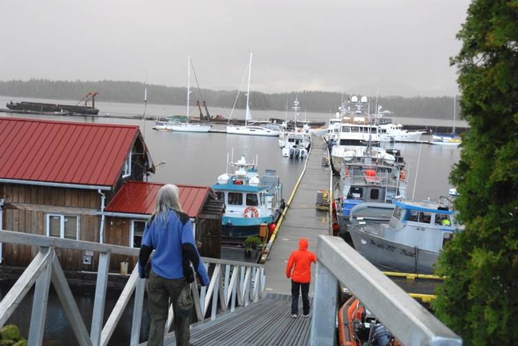
A few hours later, motoring through channels a thousand feet deep or more, we arrived at Toba Wilderness Resort and Marina. It had been a few years since we were here last. Kyle, the indefatigable owner, has done a lot of improvements. He had new concrete docks made to his specifications, tripling his moorage space. He built a handsome post-and-beam hospitality structure at the head of the dock. The grounds are well groomed and the services include wi-fi, unlimited showers, and hiking trails. He generates electricity with a small hydropower plant fed by a precipitous stream, but has added a diesel generator to handle the additional loads brought on by an increasing number of boats visiting his place.

Toba Wilderness marina docks, Tango on the left.
Peter brought Kyle a tie-dyed tee-shirt, continuing a tradition that began years ago when we first visited the marina. Peter was wearing a tie-dyed shirt from the Oregon Country Fair. Kyle admired it. Peter took it off his back and handed it to him. Kyle reciprocated with one of his tee-shirts from Toba Wildernest. Every time we’ve been back, we’ve brought a shirt for Kyle.
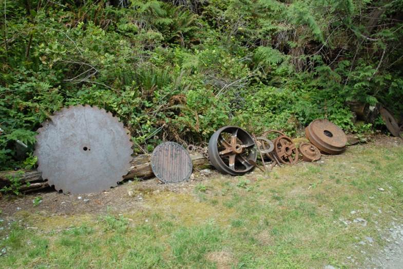
The site has been used as a logging landing. When the loggers left, they abandoned lots of junk. While Kyle was cleaning up an area, he came across these bits. There is lots more, including lots of abandoned cable.

A junky smiley-face.

Peter lounges in a hammock at a view point.

Foxglove enjoys a view.

Elderberries are starting to ripen. Salmonberries and thimbleberries are ready to eat.

A root wad stranded on the beach shows how much wood is underground.

A tree growing on a stump stranded in the intertidal zone may not have a long future.

Snow in the mountains, rainbow in the sky, boats at the Toba dock.

Tango at the Toba dock. In the foreground is a tidal grid. Boats can be floated on at high tide. When the tide goes out, the boat is high and dry for maintenance or repair. I’ve seen people apply three coats of bottom paint during one low tide at grids in Alaska.
June 28, 2018. We motored through Homfray Channel, where the depths reach 724 meters (2,375 feet). Only two miles away, Mount Addenbroke reaches 1,590 meters (5,217 feet).

We passed through Desolation Sound and anchored in Grace Harbor in the early afternoon. Five other boats were in the basin already; by the next morning, 14 were there, but it was a peaceful night. We motored through the Strait of Georgia against a light head wind that was enough to raise choppy waves that gave us a bumpy, splashy ride to Lasqueti Island.

We are back in the land of the madrone (arbutus) tree. This is an especially large specimen on Lasqueti Island.

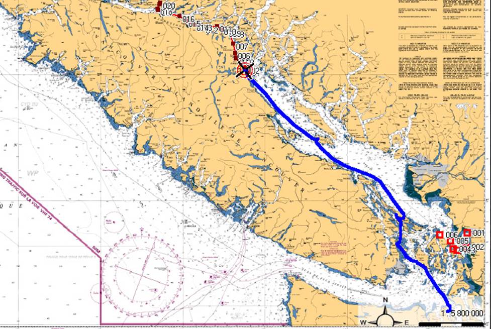
From Port McNeill to Montague Harbor. Instead of taking the customary route past Campbell River, through Discovery Passage and Seymour Narrows, we took the route through the inner rapids.
June 30, 2018. We skirted the western edge of naval activity area Whiskey Golf (WG), where torpedoes are frequently tested by US and Canadian navies. Although there were no scheduled activities today, and recreational boaters can cross, it’s my policy to avoid it. We got to Dodd Narrows, south of Nanaimo, after tidal slack and had to buck a 4-knot adverse current. The water pushed Tango this way and that, but we drove through at full power and had good control. It didn’t last long and there was no traffic.
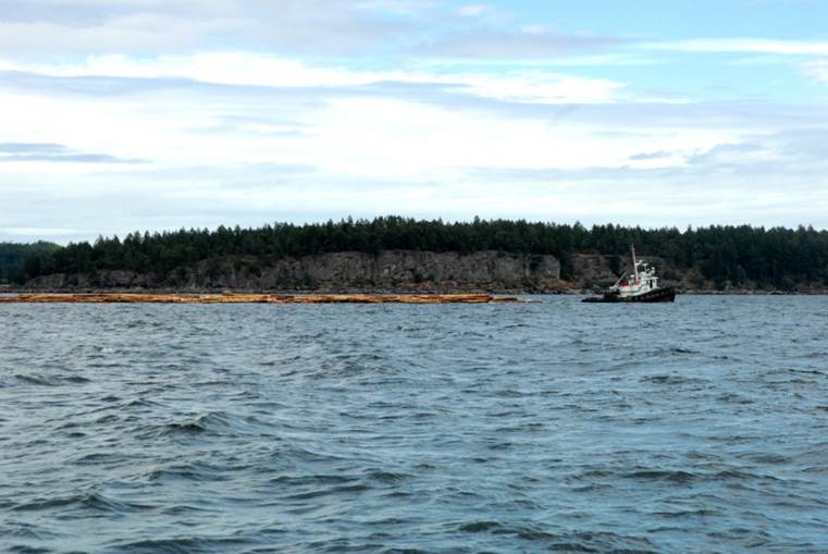
A towboat pulls a log boom. A second tug trailed behind, tending the boom.
We anchored in Montague Harbor in the Gulf Islands, one of our favorite stops. It’s a big, well-protected basin with consistent depths, good anchor holding, and lots of space. There were many boats at anchor and mooring buoys. It’s a major holiday weekend in Canada; they celebrate Canada Day on July 1.

Though there are many boats anchored, the harbor is not crowded.
We took Clara T ashore and ate in a waterside café. Sitting on the deck over the water, Peter lost his hat overboard. We finished our lunch and took the dinghy into the shoals below the café to retrieve it. Diners above congratulated us when Peter picked it out of the water.

Tug-style yachts are popular.

The trawler is another favorite style of yacht. This one is decked out for Canada Day. When sailors give up pulling lines and wrestling sails, they often move to trawlers.
July 1, 2018. We crossed the international border and checked in to US Customs at Friday Harbor. There was a stiff offshore breeze that made landing at the dock tricky. Fortunately, boaters help each other. A helpful mariner took our lines as we got close to the dock and was able to work us in against the wind. I pride myself on bringing Tango to a stop so our crew can step (not jump) off to the dock, but I was quite willing to forgo my pride and accept the help. I had the opportunity to repay my helper by handling his lines when he was ready to cast off. We cleared customs and took a space nearby on the breakwater, where we stayed for the night.
July 2, 2018. There was only a light breeze, in contrast with the day before. The forecasts from NOAA, the University of Washington, and the Canadian Hydrographic Service all predicted 20 -30 knot winds, but the evidence was contrary. We left the Friday Harbor dock, worked our way eastward through the San Juan Islands, and entered Rosario Strait, mainsail up and ready for action. But the breeze stayed light and from dead ahead (as usual), so we kept motoring across the Strait of Juan de Fuca and into Admiralty Inlet and Puget Sound. We spent the night at one of our favorite anchorages, Port Madison.
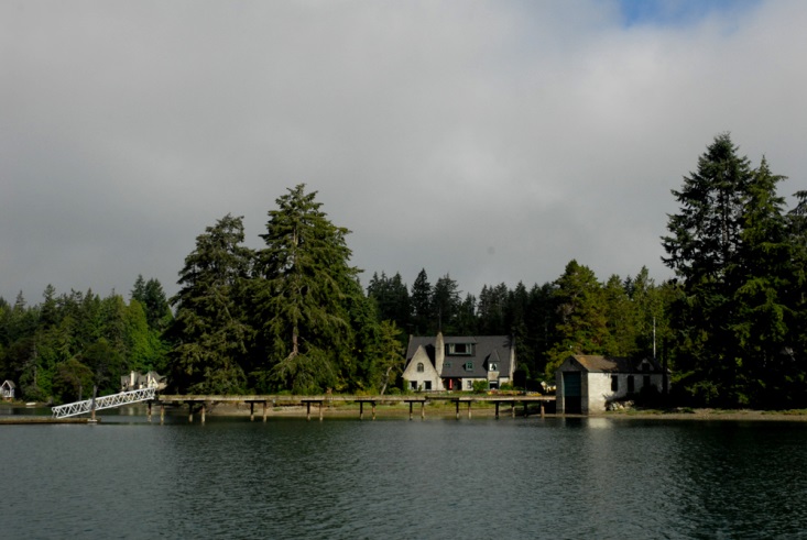
Port Madison, on Bainbridge Island, has many nice homes along its shores.

Port Madison.

This tug has been at this dock every time we’ve been to Port Madison. It appears to be retired from working service.
July 3, 2018. Except for fireworks, the night was peaceful. After a big breakfast, we raised the anchor and headed out for our last day of the voyage. Colvos Passage, west of Vashon Island, always flows north. With the north-tending ebb current, the header can add up to a couple of knots. We hugged the west shore, finding a route that minimized the adverse current and even provided a bit of a boost in back eddies. In Tacoma Narrows, the adverse current was predicted to be almost three knots, but hugging the shore gave us a good ride almost to the highway bridge. As we rounded the last point of land before the bridge, we lost our helpful eddy current and a couple of knots of speed over ground.
We landed at the dock at Swantown Marina, Olympia, Washington, and made our way to our slip. Happy to be home, but a bit sad the voyage was over, we set to cleaning, sorting, and storing our equipment, food, clothes, and myriad other things. It’s been a great voyage!
--Dennis Todd
Photos by Susi Defazio, Peter Ffolliott, and Dennis Todd.