
The log of S/V Lacuna, spring and summer 2005
Chapter 11
August 20-September 2, 2005. Ketchikan to Port McNeill.
Ketchikan waterfront
8/20/05. I spent most of the day on the computer, waiting out the big rain squalls. Between rain showers, I did last-minute shopping and got lunch at the big Safeway just a few blocks from the dock. Ed and I had agreed to meet at 1700 to review the plans for tomorrow—it looked as if the weather might be suitable for a passage. About 1630, I went to the harbormaster’s office to pay for the moorage. The harbormaster said that the fuel docks closed at 1700 and didn’t open until 0800 tomorrow. Yikes! We have to get gas, and if we have to wait until after 0800, it’ll really delay the start of tomorrow’s voyage.
I hustled back to Lacuna, prepared to cast off solo and go to the gas dock if Ed wasn’t there. Fortunately, he was on board, and we quickly took the boom tent down, disconnected the shore power cord, started OB, and we were off. Fortunately, the closest fuel dock was less than a mile away—fortunate for two reasons. OB was running on fumes, and it was almost 1700.
We got there with a couple of minutes to spare. While I was filling the tank, Ed commented that he was relieved that we got there before they closed. The attendant said they’re open until 1900 every day except Sunday—the harbormaster was misinformed. I took the time to fill the tank to the last tenth of a gallon—I don’t want to run out of gas again!
We motored back to the dock, set up the tent and power cord again, discussed the next day’s passage, and drank a beer. Then Ed went back to his motel room (Standing headroom! Shower! Flush toilet! Telephone! TV!) and I retired to my bunk on Lacuna.
8/21/05. We left the dock at Ketchikan before 0630 on a morning that was much more benign than we had expected. The wind was calm, the sea was flat, the visibility was good. We motored down Tongass Narrows. When we got into Revillagigedo Channel, there was a 7- to 10-knot wind off our bow, so we raised the sails and motorsailed close-hauled the rest of the day. Sometimes the jib came down when the wind dropped or headed us, but the mainsail kept pulling all day long. It was never enough for us to shut OB off because we needed to make mileage.
 Tongass Narrows (click here for larger image)
There was a bit of chop but with all the ballast on Lacuna and with her sails up, her motion was fairly easy. We took spray over the bow and on the coachroof more than once. There was so little in the way of interesting scenery that I spent most of the day in the cabin, working on long-term navigation. We’re hoping to get to Nakwakto Rapids by the next new moon to see the enormous tidal rapids at their maximum.

By 1600, we were anchored in the north cove of Foggy Bay, a secure and snug anchorage that we have to ourselves. The breeze has kept the bugs at bay, it’s not raining, and we’re on the verge of crossing Dixon Entrance. Life is good.
8/22/05. We got up at 0500, a bit anxious about the upcoming crossing. In persistent rain, thin fog, relatively calm seas and light headwinds, we motored out of Foggy Bay and into the mouth of Revillagigedo Channel. By 0930 we passed Lord Rock, the last bit of US land we’ll see for a while. A half hour later, with OB at three-quarters throttle, we raised the sails in a 7- to 10-knot headwind, more to steady the boat than to add speed.
Even though the sails added a knot to our speed, we had to tack back and forth because the wind was coming straight from our destination. Soon we had to take a reef in the mainsail because the waves and wind would sometimes make Lacuna heel so much that OB’s propellor would come out of the water and it would over-rev. Once reefed, Lacuna stood more upright.
It was wet from above and below. Rain fell while spray washed over the cabin and into the cockpit as Lacuna drove through the chop. Dressed in full rain suit and rubber boots, I wasn’t uncomfortable. When the bow hit a wave and threw water in the air, I’d bow my head to the elements, letting the seawater hit my cap’s bill instead of my face.
Ed had been lamenting the lack of whales the past week or so—but today, I saw a humpback at the southern end of Revillagigedo Channel. A few spouts, then flukes in the air. I hope it’s not the last I see.
For hours we motorsailed, sometimes against a current, sometimes with a current. The wind and waves eased about 1430. We dropped the sails so we could motor straight into the wind and toward our destination, the western end of Venn Passage.
I was hoping to get to Venn Passage a couple of hours earlier to catch the slack currents. Our late arrival meant that we’d be facing adverse currents, but I need not have worried. It’s an intricate passage through shoals, rocks, and islands. Well marked, it’s not hard to follow. The worst current we experienced was a two-knot header for a few tenths of a mile, hardly a problem at all.
 Venn Passage (click here for larger image)
By 1830 we were tied up at the Prince Rupert Rowing and Yacht Club marina at Cow Bay, Prince Rupert. Lacuna was moored right across the walkway from where she was tied almost three months ago. It’s good to be back.
Ed said that he tweaked his back and was in quite a bit of distress during the day. He stayed in the cabin through the day, and in the rough crossing had to move around very carefully. He’s taken a room in a hotel to stretch his back and stand upright, loading up on Valium and ibuprofen.
8/23/05. Ed came to Lacuna at 0830 to announce that he was leaving the voyage. His back is threatening to get worse. The last time he experienced symptoms like this, he ignored them and spent a week in bed and in pain as a result. He’s afraid that he’ll tweak it the same way if he continues on board, given the cramped space and lively motion. I’m sorry he’s not going to be able to continue, but I understand his dilemma.
I trudged into town with a heavy bag of laundry and ate a snack at a deli while the washing machine was cleaning my salt-soaked rain gear. The day was beautiful, warm, and sunny, so I set Lacuna’s berth cushions out to dry. She was quite a sight--the deck covered with cushions, my Goretex parka and bibs draped on the rigging to dry, and boots scattered about in the cockpit with their tongues turned out for air. Tomorrow I’ll head south, avoiding the most heavily traveled routes.

8/24/05. The tides look favorable for an early passage, but shore-side details and heavy fog kept me from leaving Prince Rupert until 1100. I filled the water and gas tanks and headed out into the harbor in fog so thick that I couldn’t see boats a hundred feet away. I was grateful for the radar and GPS.
With the radar set on the closest range, half a mile, I watched boats that I couldn’t see. I was pacing an unseen boat fifty yards off my port beam and another, larger blip on the radar screen about a quarter mile away. Near me, the motor yacht (as I was later to spy in the fog) slowed down just as I did to let the big boat make way. Then another blip came charging in from the starboard. I took evasive action, as did the cross-channel ferry when it materialized into view. Fifteen minutes later, I was trying to identify the land mass that appeared on the radar but didn’t appear on the chartplotter or the paper chart. Confused by the discrepancy between the chart and the radar, I gave it a wide berth. Good thing, too, because it was an ocean-going freighter easing into the terminal south of town.
For the next four hours, I worked my way through the fog. Traffic eased as I headed south, but constant vigilance was needed because of all the driftwood patches that the currents put together. Even at the slow speed of five knots, when the visibility is less than a hundred feet they appear with little warning.
Along the way, I passed the Lawyer Islands, with nearby Client Reefs and Bribery Islet. South of here, in Petrel Channel, are the “Math Islands”: Sine Island, Cosine Island, Azimuth Island, Tangent Island, and Logarithm Point. Next to them lies Anger Island, with Ire Inlet and Anger Inlet the favored anchorages and kayak holes. I’m sure that many people would understand the relationship between anger and math—here they are close at hand.
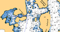
 Lawyer Islands (click here for larger image)
As I entered Ogden Channel, the fog parted and a breeze rose. It was enough to tempt me to hank on the jib and take off the mainsail cover. By the time I’d finished, the breeze had dropped so much that I raised only the jib to see whether it was worth raising the main. It wasn’t. The jib came down in five minutes.
In a narrow part of the channel, with all systems operating smoothly and little floating debris cluttering the water, I went below to fix a snack. A minute or two later, I looked at the radar and saw, straight ahead, a solid green reflection from the shore. On the chartplotter, it showed that our track had slowly curved to starboard. I must have hit the “standby” button on Ott accidentally.
Although I couldn’t see the shore, I had every reason to believe that it was close by, straight ahead. I yanked Ott off the tiller and steered hard to port until we were back on course again. Yikes! Had I not had the radar and chartplotter on, I might not have realized my mistake until I ran aground at five knots. So far, the closest I’ve come to grounding was when I left the rowing and yacht club harbor this morning—the tide was low and I wandered a bit out of the dredged channel next to the small-boat dock. The centerboard rumbled over the bottom and I quickly turned back into the channel. I definitely want that to be the worst (and only) grounding of the voyage.
I anchored in Captain Cove a quarter mile away from another sailboat, the only boat of any kind I’ve seen all afternoon.
8/25/05. I got up at 0600 to catch the southbound ebb current. In the cove, the fog was thin but it thickened when I got out into Petrel Channel. With the radar, chartplotter, and course laid into the GPS, I was navigating by video. With a 1- to 2-knot boost from the current, I made good time. Even though there was no boat traffic (I didn’t see another boat all day), dodging logs and sticks made life interesting. In very flat water, the radar can see some floating debris. Large diameter logs show up. A deadhead sticking upright a couple of feet above the surface showed up brightly on the screen. But when the chop rose, the waves reflected spurious signals, so I had to tweak the sea state adjustment to reduce the clutter, and the flotsam was again invisible.
 A sun dog in Petrel Channel
Around noon, I rounded Foul Point on Anger Island and entered Principe Channel. The wind rose to a 7- to 10-knot header, raising uncomfortable chop. I worked my way through it, boat speed dropping because of the chop, headwind, and increasingly adverse current. I had another dozen miles to go to my intended anchorage, Mockton Inlet, but I turned to port and headed into Miller Inlet, where I set anchor by 1330. I’ve seen no boats today. There’s another storm system with southeast winds headed my way, so I might be staying here tomorrow.
8/26/05. I got up an hour and a half before dawn and made my way out of Miller Inlet as soon as I could see, hoping to get ahead of the predicted winds. There was thin fog, visibility about half a mile, a light breeze, and no traffic until noon, when I saw a yacht and a couple of fishing boats. It rained and rained some more. With such limited visibility, I wasn’t interested in touring, so I just kept pressing on, finally reaching Emily Carr Inlet. After passing though a very tight channel, probably less wide than Lacuna is long, I found a bombproof little anchorage that showed no sign of human occupation.
 Emily Carr Inlet (click here for larger image)
8/27/05. After I worked my way out of that tight little cove, I set off under low overcast and rain showers. Traffic started to pick up. I saw my first cruise ship in a while. The wind rose, and although it was on the nose, it was enough to get me to hank on the jib and take off the mainsail cover. I’ve learned not to be too eager, however, and soon the wind dropped. I put the sails away without raising them even once.
I was in a bit of a rush to get to Klemtu, a First Nations town, to get fuel. In their culture, making money is less important than a lot of other activities, and I knew that they’d keep banker’s hours. The cruising guides said the fuel dock was open until 1700. I kept the throttle open, Lacuna just short of hull speed, and made it to the fuel dock by 1640. No attendant was there. A fishing boat with a couple of friendly young guys pulled up, desperately needing hydraulic fluid (they almost couldn’t raise the anchor on the borrowed boat this morning because the hydraulic windlass was gasping for fluid). I called the operator on the VHF. He said he was just sitting down to dinner and would be out to help us when he was done.
 Klemtu (click here for larger image)
I knew better than to be impatient, but I had enough fuel to get to Shearwater, and I thought of pressing on. More than two hours later, just as I was ready to pull away and find an anchorage, he pulled up to the fuel dock in his pickup. Much to the dismay of the fishermen, he had no hydraulic oil, but he did sell me gas. He was humorless and distant—perhaps I’d feel that way too if I had to go back to work after dinner.
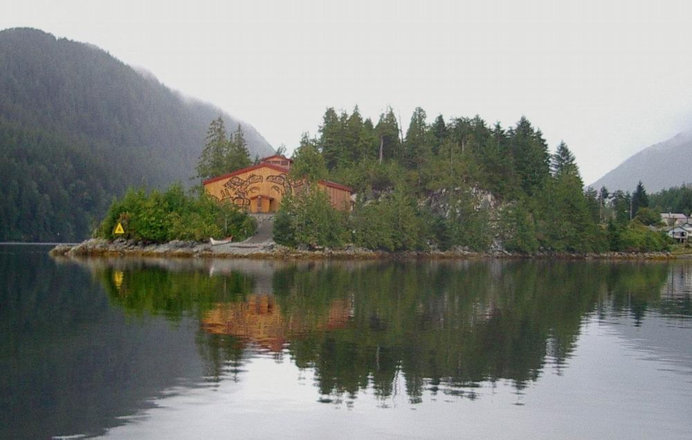
Klemtu is a prosperous-looking First Nations town. There’s a Big House that is the obvious pride of the community—it’s big, imposing, and handsomely decorated. On the point of land overlooking Klemtu harbor, the building is tastefully illuminated at night. There are many well-kept houses, often two stories, with brightly-colored metal roofs and fresh-painted siding. New buildings are going up in several places.

Klemtu Big House (click here for a larger image)
The Indian towns in Canada seem much more progressive and well-kept than the Indian towns in the USA. I’ve often speculated on what accounts for the contrast. One big difference is that in Canada, the bands occupy sites on their ancestral land—they haven’t been forcibly moved to some God-forsaken desert that no white man wanted.

I stayed at the guest dock at Klemtu, got a shower, and holed up for the night. Driving rain hit Lacuna astern, scattering rain through the companionway and into my face. I battened down the hatch and was just going to sleep when a cold drop of water hit square in my ear and ran down my ear canal. I woke up instantly.
The sealant had failed in a deck fitting over my head, allowing enough water to seep through to release a drop every half hour or so. I didn’t need more than one to convince me to move. Fortunately, the berth is long enough that I could slide away from the drip and still have enough room to stretch out.
8/28/05. It took a bit longer to get going this morning than usual. Pouring rain provided motivation to stay in the cabin. I ate breakfast, fixed coffee, shuffled charts into and out of the locker, and finally, when there was a break in the rain, called my parents. My calls to them are a Sunday morning ritual, often observed at other days of the week during this voyage. I was pleased to find that they were doing well and, as they always seem, in good spirits.
Immediately after I left the dock I had to retire Ott Sr., the Autohelm tillerpilot that I picked up at a swap meet. I’d been relying on it during wet weather because the new unit, Ott Jr., has defective seals—it gets waterlogged if it stays out in the rain. But Sr. wasn’t up to the job this morning, turning poor Lacuna hard one way or the other, wandering off in odd directions toward the shore (in this narrow passage, there’s not much room for error). It seemed like a case of terminal dementia, so I put OB in neutral and let Lacuna drift while I removed Sr. and made a raincoat for Jr. out of plastic film and black electrician’s tape. It’s not pretty, but it works. It’s not a good advertisement for Raymarine.
As a sailor, I feel duty-bound not to complain about the wind. I might complain about the lack of wind, but I should be grateful whenever there’s wind. However…
It seems as if there are two kinds of wind in the Inside Passage: headwinds that raise nasty chop and thwart progress and tailwinds that are just strong enough to push the motor’s exhaust back into the cockpit. Rare indeed is a beam wind. I thought I was just imagining things when it seemed as if the wind was always in my face, but today I had concrete evidence.
At Lacuna’s masthead is a wind vane. Trailing behind it, offset at 50 degrees from the centerline, are two flags that show the no-go zone. If the tail of the vane is between those flags, Lacuna is pointed too close to the wind to sail—she can sail upwind, but only within 50 degrees of apparent upwind. Closer than that and her sails stall, just as an airplane wing stalls if it has the wrong angle of attack on the air. She comes to a stop, “in irons,” unable to move unless she can be backed off the wind. Today, the vane never left the no-go zone, no matter which way my route took me.
When I left Klemtu, the wind was on the bow as I headed SSE in Finlayson Channel. When I turned 90 degrees to port into Oscar Passage, the wind followed me exactly as I rounded Legace Point. I watched the vane—the tail never left the no-go zone as I made the turn. As I headed ENE it was directly on the nose throughout Oscar Passage, and when I turned 90 degrees to starboard at Buckley Head and entered Mathieson Channel, it was still on my nose—but it was now coming from the south. I was tempted to complain, but I knew it would do no good.
 Oscar Passage. Headwinds all the way. (click here for larger image)
 Rocks and islets in Seaforth Channel
The day’s voyage was uneventful except for increasing traffic as I got into more heavily-traveled routes. At one point, I was passed by a cruise ship, two tugs pulling barges, and a couple of yachts. By 1700, I was tied up at the dock at Shearwater Marine, Bella Bella. I took a shower, turned on the electric heater to dry Lacuna’s cabin, ate dinner at the restaurant, and now I’m ready for bed.
I realized that I have reached a turning point in the journey. Thoughts of people and projects at home intrude into my consciousness more and more. As I was reviewing the next day’s route, I could have chosen between the channels I’d already passed through, dependable and direct, or an outside route that would take me to the wild shores of Queen Sound. For the first time, getting home quicker sounded more attractive and I laid in a course over the well-traveled route.
If I could end the voyage today, I wouldn’t do it. I want to complete the journey, and there are still some attractions that I’m going to take the time to see, but I feel my pace toward home is picking up a bit. A couple of days ago, I turned on the stereo and played music for the first time in months. Usually I like to listen to the sounds around me, but I felt a little lonely, I guess, and needed to hear familiar music.
8/29/05. I had a good day’s passage despite my reservations about having plotted such an ambitious journey: 52 nautical miles. The forecast predicts a west wind tomorrow, then back to southeast winds, the dominant theme in the past few days. It looks like an opportunity to cross Queen Charlotte Sound in style—20 knot westerlies would be a beam or broad reach to the other side of the sound—if I can start the crossing early in the morning. Fury Cove, reputed to be an excellent anchorage, is one of the closest harbors to the crossing, so that was my destination. Just in case the weather turned against me, I plotted courses into a couple of anchorages along the way.
I had no idea what to expect for currents. I could find no indication on any chart, tide table, secondary current table, electronic charting software, or digital current and tide calculator. It’s only two days after the moon’s third quarter and the minimum (neap) tides that occur then, so I was hoping that they wouldn’t be too adverse. In the long, straight channels that I would traverse today, there would be few opportunities to find eddies in a contrary current.
 Lacuna at Shearwater Marine
I didn’t get away as early as I had hoped—I had breakfast at the Shearwater restaurant and did the navigation that I was too tired to do last night. Pulling away from the dock at 1000, I expected to end up at one of the closer anchorages. The 1-knot adverse current I soon experienced in Lama Passage made me resigned to the likelihood.
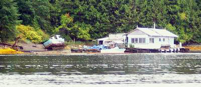 Lama Passage floating home
Once I turned into Fisher Channel, I got an immediate boost, a helpful current that carried me almost to my destination. The wind rose, so I put up the sails and motorsailed for hours, from close-hauled to broad reach. Sometimes the wind would die so I’d drop the jib and keep the mainsheet tight, motoring along until it picked up again. The sky was beautiful with multiple levels of picturesque clouds.

All day, I was plagued by distracting thoughts, not focusing on here-and-now. Preoccupied with plans for projects at home, thinking about the classes I’m teaching this fall, I found myself ignoring the scenery and neglecting the mechanics of passage-making. But a mile before Fury Cove, a whale breached twice and slapped the surface a number of times with his pectoral fin. That caught my attention and brought me back to the present!
As I got close to Fury Cove, I saw a power yacht pull into its entrance. Through openings in the reefs that surround the cove I could see several other boats. Too crowded for me. So I quickly set a course to nearby Frigate Cove, where Lacuna had the place to herself.
8/30/05. I got up before dawn and was eager to get underway to complete the crossing of Queen Charlotte Sound, but I had to temper my haste because I didn’t want to get to my destination too early. I was headed past Cape Caution to Slingsby Channel, which leads to Nakwakto Rapids, one of the world’s fastest reversing tidal overfalls. Behind the rapids lie long fjords containing immense volumes of water. When the tide rises in the ocean, it climbs above the sill at the rapids and water pours through the narrows into the fjords. When the tide is ebbing, water flows out so fast that Turret Island (known locally as “Tremble Island”) in the middle of the narrows is said to shake with the force of the current, which has been measured at as much as 16 knots. As the water rushes out through Slingsby Channel, it can reach currents of 6 or 8 knots, much more than I wanted to deal with.
I wanted to time my arrival on the last of the rising tide so that I could get a ride in through the outer narrows in Slingsby Channel to Treadwell Bay, the anchorage nearest the rapids, but I didn’t want to get there too early and risk big currents and swirls. So I restrained my enthusiasm for getting underway even though the wind was calm and the sea was about as settled as it ever gets in the North Pacific.
For once, there were hours when the wind wasn’t directly on the nose (but close!). It was enough off the bow that I could sail close-hauled, so I raised the sails but kept OB running. A couple of times it seemed as if it had built enough that I could turn off the motor, but both times the boat speed soon dropped below four knots and I powered up again. It rained, then stopped raining, then rained some more. Lacuna rocked and rolled in the swells. Miles went by with nothing to see but a few offshore islets and rocks.
As I rounded infamous Cape Caution the dying wind backed to bow-on and stayed that way for the rest of the voyage. I left the mainsail up because it helped stabilize Lacuna and keep her from rolling too much in the swells, but as we closed in on Slingsby Channel I put the sails away.
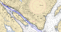
 Nakwakto Rapids (click here for larger image)
The entry to the channel went like clockwork. It was an hour before high tide slack, and the rising tide pushed me through with a three-knot boost and little turbulence. Without any problems, I found my way back to the tiny cove at the north end of Treadwell Bay and dropped the anchor by mid-afternoon. The day was so warm that I washed my hair and slept in the cockpit for an hour. Blessed be the bugs in their absence!
A dozen seals hauled out on a rock 100 yards from Lacuna. Every so often a couple would start splashing in the shallows and most of the animals would slide hurriedly off the rock into the water, only to climb back on one-by-one until they were again close packed. Little grunting sounds came from the group until I inadvertently clattered the deck brush against the coaming—they immediately fell silent. My activities on deck as I hung out my rain gear and organized the cockpit didn’t seem to faze them except that they remained silent.
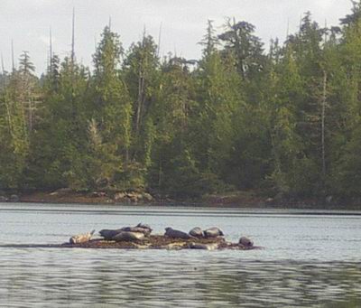 Seals on a rock near high tide.
Two small waterfalls cascade down the rocks next to Lacuna’s anchorage. I think back on some of the noisy harbors I had down south, noisy because of traffic or airplanes or just the background noise of “civilization,” and I marvel at the contrast I’ve experienced in these waters. Sometimes for days I hear no sound but my own noises and the music of nature.
8/31/05. Wanting to make the transit through Nakwakto Rapids just before slack at 0912, I weighed anchor at 0830, set OB at high idle, and headed out to make the 1.7 mile passage to Turret Rock. I was facing the last of an ebb tide, so if the current was stronger than 3 knots, I’d just idle against it until it dropped. I wanted to savor the passage through this world-famous rapids. Lacuna met some turbulence that banged the centerboard in its trunk—sticking down in the water, it and the hull sometimes feel currents that differ. Steering was casual, although I had to pay attention as the swirls slowly spun Lacuna one way or the other.
Speed over ground dropped to 1.5 knots as I neared Turret Rock. Trees on the rock are festooned with signs from intrepid boaters that have visited. Maybe someday Lacuna’s sign will join them, but not today. I was happy to make an easy passage through, so happy that I turned back to check out the dinghy landing on the small island that makes one side of the rapids and the rough-hewn platform reported to overlook the rapids. After seeing them both, I turned toward Belize Inlet.

My illusions that this is wilderness were soon shattered as a floating logging camp came into view along the shore. The hillsides are marred by clearcuts and logging roads. A speeding water taxi came through the rapids and zoomed past. A plane flew over. I watched a log truck dump a load of logs into the inlet. A tug stood nearby, waiting for the boom to be filled.
 A truckload of logs splashes into the sea.
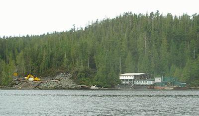 A logging camp on barges.
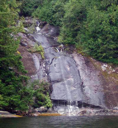
It was raining, and I was beginning to regret my decision not to press on to Port McNeil, but the guidebook promised scenery, and I am still thrilled by exploration, so I pressed on. The further I got into Belize Inlet, the better it became. The rain was incessant but not heavy and the clouds allowed views of the highest scenery. Waterfalls plunged down steep rock faces. Clearcuts became fewer. A formation reminiscent of Half Dome in Yosemite came into view, a high-volume waterfall in the foreground.
 "Power Wash Falls," Belize Inlet
A low-volume waterfall.
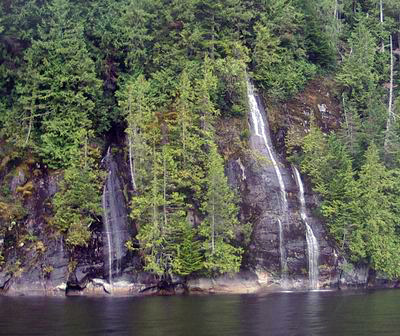
A multiple-channel waterfall (click here for a larger image)
 A multi-step waterfall.
I turned into Alison Sound, a narrow channel surrounded by cliffs. The rain made me decide to take the first good anchorage I came to in hopes that tomorrow will bring better weather for photography, because this is a spectacular place. By 1415 I had set anchor in Peet Bay, a secluded little cove that seems very well protected. Unfortunately, as soon as I turned OB off, I heard the sound of chain saws and a helicopter. I’d rather hear nature, but in this case, I’d rather hear music, so I put on a CD of Paul Desmond and his sweet alto sax.
9/1/05. It rained all night, all morning, and most of the day. Giving up on the thought of seeing the scenery deeper in Alison Sound, I set a course for Nakwakto Rapids and beyond. One big advantage to rain—it brings out the waterfalls. I’ve never seen so many. Nearly every rock face (of which there are many) has wisps, trickles, rivulets, sheets, cascades, or torrents pouring down.

A dozen waterfalls in a quarter mile (click here for larger image)
As I got closer to the rapids, the rain eased but the scenery became less interesting. I stayed close to shore, in water hundreds of feet deep, to see the details and to avoid looking at the clearcuts, the mange of human industry, that defoliated the hillsides.
A warning came from the Coast Guard: an orca in Nootka Sound has contacted several small craft, showing special interest in the keels and rudders of sailing vessels. Substantial damage has resulted. Mariners are urged to avoid certain areas. That’s on the other side of Vancouver Island from me, so I’m not worried about Lacuna being mugged by an orca..
I got to the rapids an hour early, but it was no trouble passing through. There was some rocking and rolling, twisting and turning, but no big deal. I continued south in Schooner Channel, still against the currents at the last of the flood tide, and found a secure anchorage in Shelter Bay.
Today, Lacuna passed the 3000-mile mark on this voyage. She’s a well-traveled little trailersailer!
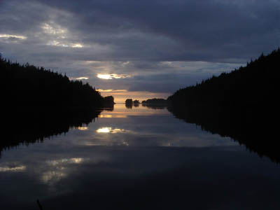 Shelter Bay sunset
9/2/05. The day dawned without rain but that respite was short-lived. Almost as soon as I pulled out into Queen Charlotte Strait the rain began. It persisted for several hours, sometimes a driving downpour, then let up as I neared Port Hardy, where I took on gas. I immediately set off for Port McNeill, just 20 miles away, where I landed by 1600. I plugged in the shore power cord and started the electric heater—Lacuna’s cabin is so damp that mildew is starting to grow on the walls. After a shower and a halibut burger, I returned to the boat loaded with enthusiasm for projects—tomorrow.
--Dennis Todd